

A submarine eruption north of Papua New Guinea may be building new land while satellites track its evolution from above.
Oceanographers often point out that the surfaces of the Moon and Mars are mapped more precisely than much of the deep seafloor on Earth. That gap is especially clear in the Bismarck Sea, a deep basin north of Papua New Guinea. Its seafloor is geologically complex, with faults, volcanic structures, rifts, scarps, active subduction zones, and spreading zones lying at depths that are difficult to map in fine detail with sonar.
On May 8, 2026, satellites picked up signs of an unexpected underwater volcanic eruption in the Central Bismarck Sea. For volcanologists, the event highlighted a major problem: there were no detailed maps of the region, and the deep water setting of the eruption remains poorly understood.
The eruption is believed to be taking place along Titan Ridge, about 16 kilometers (10 miles) southeast of a submarine eruption recorded in 1972. Still, scientists do not yet agree on exactly which volcanic feature is active, how deep the vent was before the eruption, or when it last erupted.
“The good news is that there are huge opportunities to explore and learn using both government and commercial satellite platforms already in orbit,” said Jim Garvin, the chief scientist at NASA’s Goddard Space Flight Center.
Satellites reveal the eruption
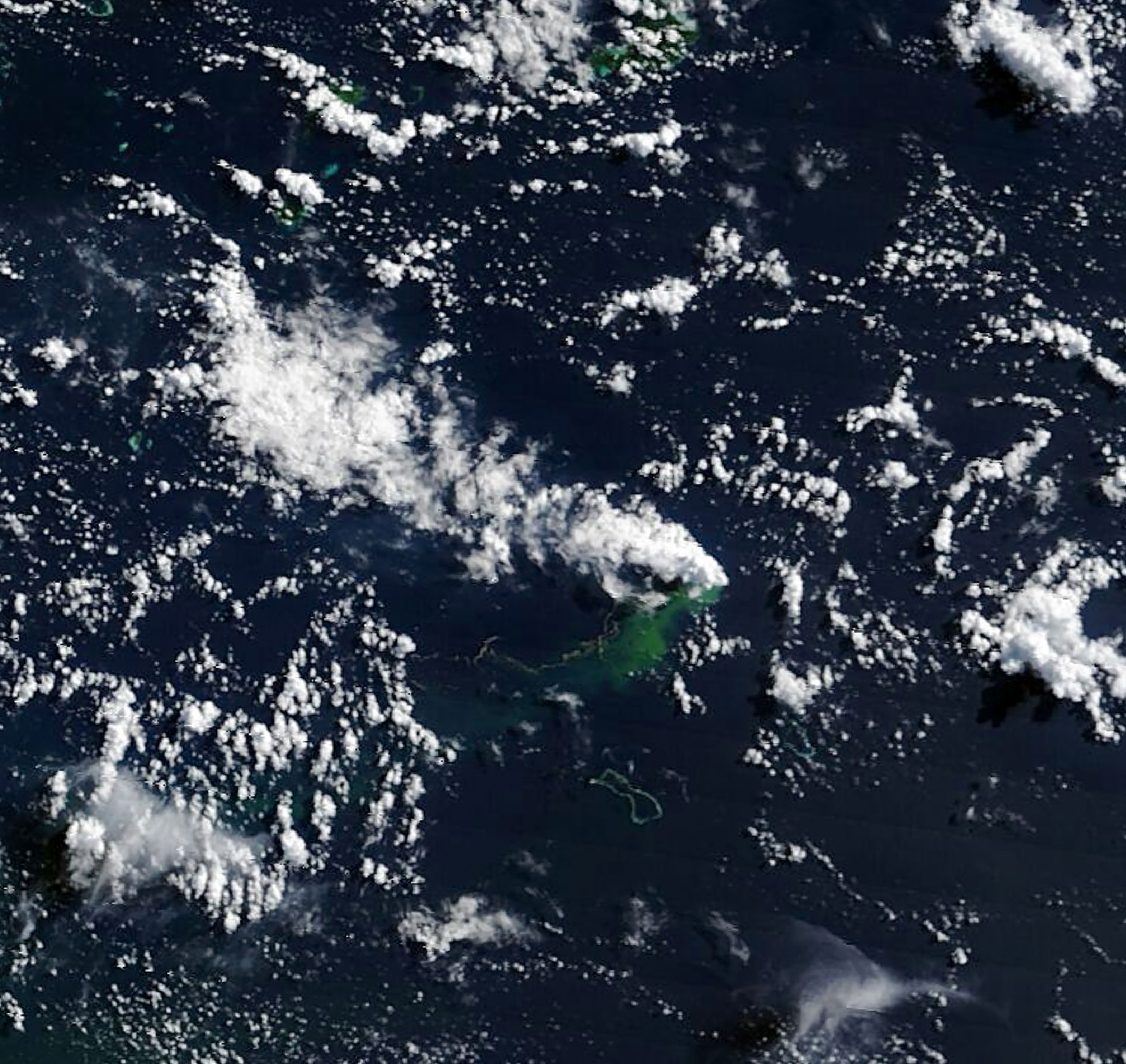
The clearest early evidence began with a small cluster of earthquakes detected by seismometers on May 8. Soon afterward, satellite observations showed unmistakable signs of a submarine eruption. Starting May 9, NASA’s Aqua and Terra satellites recorded optical images of white, steam-rich volcanic plumes rising into the atmosphere. NASA’s PACE (Plankton, Aerosol, Cloud, Ocean Ecosystem) satellite also detected discolored, disturbed water around the eruption site with its ocean color sensor.
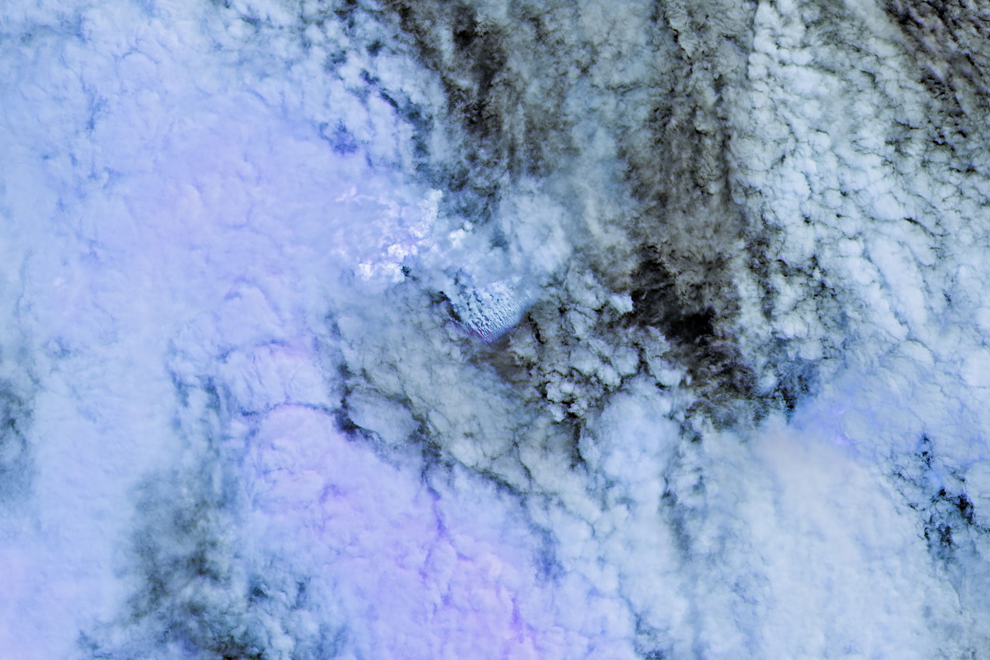
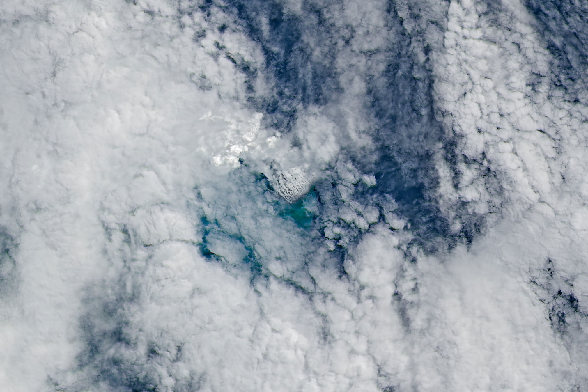
Additional satellites saw ash plumes rising several kilometers into the air. More detailed imagery from the European Space Agency’s Sentinel 2 and NASA/USGS Landsat 9 (top), collected on May 10 and 11, respectively, showed activity close to the ocean surface. The image at the top right shows the same area in false color (bands 7-6-5), with the inset revealing the eruption’s infrared signal. On May 12, the VIIRS (Visible Infrared Imaging Radiometer Suite) instrument on Suomi NPP detected heat anomalies spread across roughly seven square kilometers.
“There must be a lot of hot material near the surface to generate so many thermal anomalies,” said Simon Carn, a volcanologist at Michigan Tech. “This suggests a fairly shallow eruption vent—much shallower than what’s implied by the existing bathymetry, which shows water depths of several hundred meters or more.”
A new island may form
Optical satellite images show vigorous activity in shallow water, including large areas of discolored water and many steam and ash vents spread across the surface. Medium and high resolution sensors from government programs and commercial satellite companies have also captured broad pumice rafts (floating volcanic rocks) forming long streaks in surface currents in recent days.
“We’re now eagerly waiting to see if a new island is about to be born—something that we’ve only rarely been able to observe with satellites as it happens,” Garvin said. If new land appears, volcanologists will monitor how it changes. It might grow into a tuff cone with a vent crater that lasts for some time, or it could quickly collapse and wear away. The eruption could also become far more explosive if seawater reaches the shallow magma chamber that has pushed up within the growing underwater feature.
Explosive risk appears limited
So far, this eruption has been much less explosive than recent submarine eruptions such as Hunga Tonga Hunga Ha’apai in 2022 and Fukutoku Okanobain in 2021. Carn said the event is unlikely to become highly explosive because it appears to be linked to a volcanic ridge near the meeting point of a transform fault and a back arc spreading center. “Spreading centers are associated with less explosive activity, while the most explosive eruptions are usually along subduction zones and involve large stratovolcanoes.”
It is not yet clear how long the eruption will continue. The 1972 eruption in the same general region lasted only four days, while another submarine eruption about 100 kilometers away in the St. Andrew Strait in 1957 continued for nearly four years.
A rare natural laboratory
Garvin and scientists at other institutions are watching the eruption closely. He plans to study radar data from the NASA ISRO NISAR satellite and the Canadian Space Agency’s RADARSAT Constellation Mission to map any new land that appears and track how its shape changes. If a lasting island forms, Garvin also sees a chance for researchers, or “island-nauts,” to visit and study how a young island responds to plant and animal colonization, rainfall, chemical weathering, and other forms of erosion, similar to work carried out after the Hunga Tonga Hunga Ha‘apai eruption.
“This new eruption could present an even better opportunity for ‘island-naut’ exploration as we prepare to return to the Moon with women and men via Artemis IV,” he said.
Never miss a breakthrough: Join the SciTechDaily newsletter.
Follow us on Google and Google News.
Full article can be found at: https://scitechdaily.com/nasa-satellites-spot-rare-underwater-volcano-eruption-that-could-create-earths-newest-island/


